October 8, NOAA issues an ENSO alert: El Niño continues to strengthen, with a strong-to-very strong El Niño likely through January-March 2027 (remaining greater than an 83% chance).
What does this mean for snow in the Upper Colorado headwaters?
A strong El Niño has mixed effects in that region. It can favor wetter conditions in the southern portion, but does not reliably produce greater snowpack across the headwaters. Other climate indices we have studied point toward drier winter–spring conditions in the Four Corners region: the negative phase of the Pacific Decadal Oscillation, a pattern of North Pacific sea surface temperature variability, and the positive phase of the Atlantic Multidecadal Oscillation, associated with a warmer North Atlantic. These influences shift the odds, but do not determine the outcome of any individual winter.
NOAA considered the negative Pacific Decadal Oscillation in its October discussion, but judged that the strong El Niño may limit its influence this winter. Their three-month precipitation outlooks combine climate models, historical relationships, and forecaster judgment.
Latest ENSO alert, latest outlook discussion. NOAA updates these three-month precipitation outlooks monthly. Most recently updated 90-day forecasts.
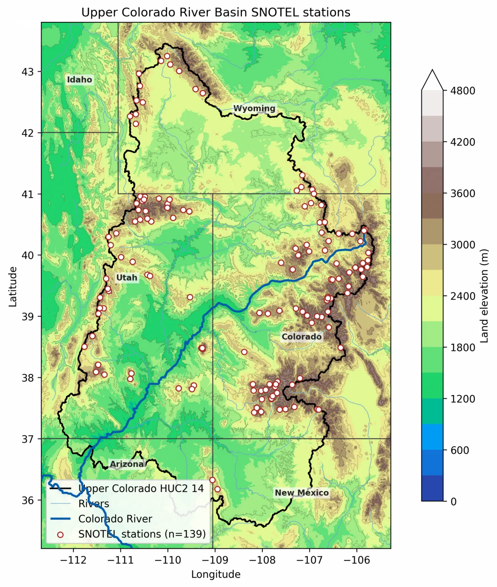
NOAA Seasonal Outlooks of Precipitation
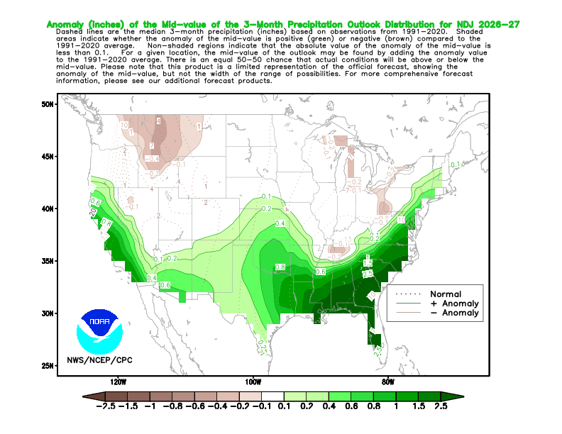
NOAA's seasonal precipitation outlook for Nov-Dec-Jan 2026-27 shows above-normal median precipitation (an additional 0.1 in) in the southern part of the upper Colorado headwater basin and normal amounts in the northern portion.
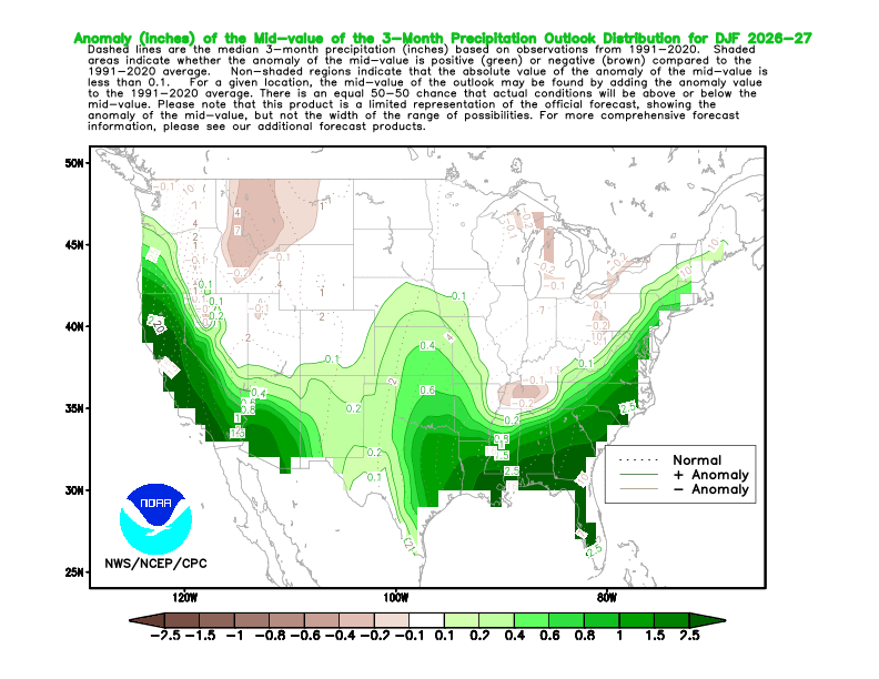
NOAA seasonal precipitation outlook for Dec-Jan-Feb 2026-27, showing higher-than-normal median precipitation amounts of 0.1 in moving northward and small areas of 0.2 in the southern portion of the upper Colorado headwater basin.
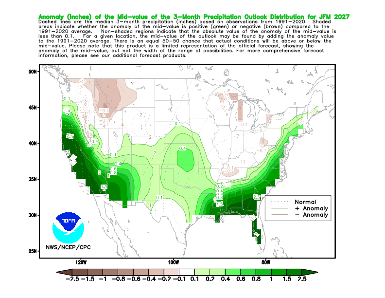
NOAA seasonal precipitation outlook for Jan-Feb-Mar 2027, showing higher-than-normal median precipitation amounts of 0.1 and 0.2 in moving northward, and 0.4 in Arizona and western New Mexico.
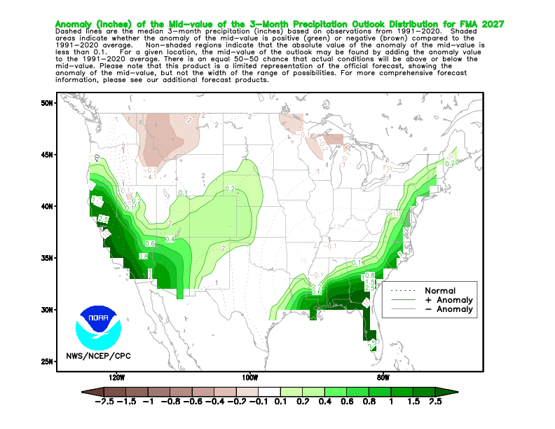
Feb to Apr 2027 is similar to Jan to Mar 2027, but with an expansion of the 0.2 in median contour.
When Hurricane Rachel’s Tropical Moisture Turned to Mountain Snow
October 11, 2026
Remnants of Hurricane Rachel supplied tropical moisture to the western United States. As that moisture interacted with a colder storm from the Pacific Northwest, rain changed to snow at high elevations. October mountain snow is not unusual by itself, but in this case it had a connection to a former eastern Pacific hurricane.
Read more under "West" at the Drought Monitor Narrative
Water vapor imagery from NOAA's GOES West (GOES-18) shows the remnants of Rachel moving over the western U.S. after making landfall in Baja California. The storm brought heavy rainfall throughout the region and snow to the higher elevations. Timespan: Oct. 10, 2026 (00:00 UTC) - Oct. 11, 2026 (21:40 UTC) [Credit: NOAA, CSU/CIRA]
Tropical Moisture Fuels Southwest Storms, October 20–22, 2026
October 20-22, 2026, an upper-level low near California drew tropical moisture northward ahead of it into the Southwest. That moisture, combined with lift and strong winds aloft, supported heavy rain and severe thunderstorms across parts of Arizona, with flash-flood concerns extending into southern Utah and southwestern Colorado.
Most recently updated NOAA forecast discussion
Caption: Midlevel water vapor imagery on October 21, 2026, 1540–1940 UTC, shows an upper-level low offshore of California and a band of moisture extending northeastward toward Arizona and the Four Corners region. Yellow and orange indicate relatively dry air aloft.
Video credit: NOAA/NESDIS/STAR, GOES-18 (GOES-West), ABI Band 9 (6.9 µm).